Towards Millimeter-Accuracy Positioning
Advanced inventions and technologies have become essential to our everyday life. Rapid development of Space Industry, Geodesy and Digital Cartography, as well as innovations in Civil Engineering, Agriculture and Robotics demand more accurate and reliable positioning systems.
Receivers of the NTL10X Model Line
Every day, many new technological solutions occur in the world; however, it is a challenge to create a product able to meet the market demand.
Over thirty years, the NTLab has been developing and producing integrated circuits, receiving devices and equipment for high-precision positioning.
NTLab offers the NTL10X model line of high-precision positioning receivers able to determine coordinates with millimeter accuracy. The specialists of NTLab have designed the key components (both analog and digital ICs), developed the software and product design of their receivers.
As an example, Figure 1 shows a two-antenna positioning module NTL104. It is able to determine the coordinates of an object, its velocity, the current time, and the angles of spatial orientation: Heading and Pitch.
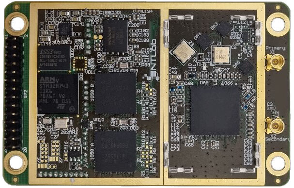
Fig.1. NTL104 – Dual antenna high performance OEM GNSS module with extended functionality RTK/PPP INS
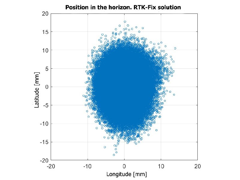
Fig.2. Results produced by NTL104 in RTK-mode
The NTL10X modules are multisystem multifrequency receivers operating at the geodetic level of accuracy, as proven by numerous comparisons and experiments, both in post-processing and real-time modes.
Figure 2 shows the results produced by the NTL104 module working for 2 and half days in the RTK mode. The Trimble BD930 receiver was used as a base station. The horizontal accuracy was about five millimeters (20 m baseline), which corresponds to the best industrial performance for this kind of equipment. These results indicate not only the high-accuracy positioning but also the compatibility between the NTLab and Trimble receivers.
PPP operation in static mode using the example of measurments from IGS stations (SP3 Final orbits & clocks)
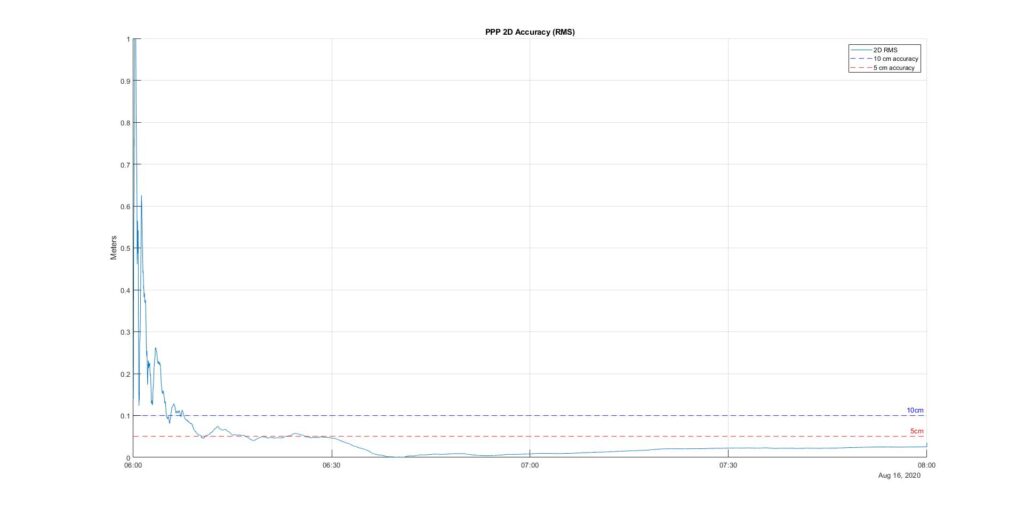
Fig.3. Convergence of PPP-solution in static mode
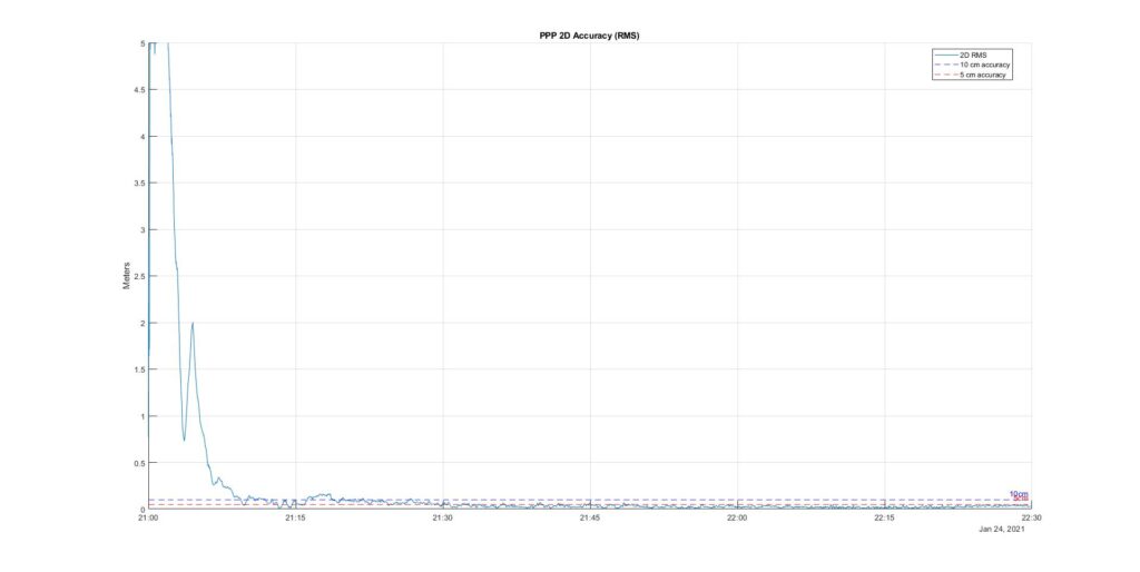
Fig.4. Convergence of PPP-solution in kinematic mode
The specialists of NTLab have developed PPP algorithms for embedded software of their navigation modules. The same algorithms are used in PC software with two modes of operation: real-time and post-processing. Currently, the dual-frequency PPP mode is supported for three navigation systems: GLONASS, GPS, and Galileo. There are plans to extend this list with other satellites systems and signals as PPP corrections become available for these signals. All PPP data streams that correspond to SSR messages as defined by RTCM 10403.3 can be used for positioning in PPP mode.
Figures 3 and 4 show the convergence graphs for the PPP solutions in static and kinematic modes, respectively. The results were obtained for the NTL104 positioning system in real-time mode, with a fixed antenna.
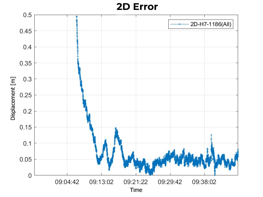
Fig.5. – Compare trajectory PPP with RTK solution
Figure 5 shows the accuracy of PPP position estimated with respect to RTK position served as a reference. After a period of initial convergence lasting about 20 minutes, the difference between the horizontal PPP position and the reference position was 5 cm. The results were obtained on the NTL104 module.
For all of the above results, the dual-frequency (L1 / L2) dual-system (GLONASS / GPS) mode for GNSS-data processing was applied. The results demonstrate the capabilities of the RTK and PPP algorithms implemented in the positioning modules of NTLab.
These high-accuracy positioning algorithms can be ported to any hardware and software platform that meets the minimum memory and performance requirements in real-time mode.

